


Sustainable Urban Planning: An introduction to Irish spatial policy in 2025
The Irish Green Building Council is launching a new blog series, “Sustainable Urban Planning,” by Michael Hayes, an...

About the author

The Irish Green Building Council is launching a new blog series, “Sustainable Urban Planning,” by Michael Hayes, an urban design researcher with the IGBC, exploring what a sustainable built environment could look like at the neighbourhood and settlement scales.
This first post outlines the framework through which Irish spatial policy is made, highlighting the different scales of plan making, categories of plan and how they intersect, and the range of organisations primarily involved in their production. Future articles will cover topics including population growth targets and distribution, projected urban densities, and the implications of compact growth concepts in an Irish context.
The structure of plans
Plans in Irish spatial policy are hierarchically structured, from the national to the local level (OPR, 2022). On this basis, policy is intended to operate within a nested framework, with policy decisions made at a higher level in the hierarchy guiding smaller-scale decisions at the lower levels.
Across this spectrum of plans, a wide range of acronyms appear with notable regularity. With that in mind, the full title of plans are typically used throughout the text, with a glossary of terms provided at the end of the article.
1. National
At highest level, the national scale, the National Planning Framework (NPF) set out strategic outcomes and associated investment priorities until 2040. It encompasses broad goals ranging from rural economies and resource management to the implementation of sustainable technologies and urban growth policies. These are outlined in terms of National Policy Objectives (NPO), of which there are 108. This article series will focus on those NPOs concerned with population growth and distribution, as well as those associated with the form and location of future urban expansion. The National Planning Framework is prepared by the Department of Housing, Local Government and Heritage, and approved by both Government and the Oireachtas. It was first published in 2018 and revised in 2025.
2. Regional
At the next level, the regional scale, Regional Economic and Spatial Strategies (RSES) incorporate environmental, economic and planning issues. Given their areal remit, a Regional Economic and Spatial Strategy can be more spatially specific, extending or detailing national objectives described in the National Planning Framework, supported by regionally focused mapping and data. Regional Economic and Spatial Strategies are particularly notable as the source of regional-level settlement hierarchies, as well as being responsible for the development of Metropolitan Area Strategic Plans (MASP) for each of Ireland’s five cities: Dublin, Cork, Galway, Limerick, and Waterford.
Regional Economic and Spatial Strategies are produced by each of the three regional authorities: the Eastern and Midland Regional Authority, the Southern Regional Authority, and the Northern and Western Regional Authority. The Eastern and Midland Regional Economic & Spatial Strategy 2019-2031 was published in 2019, while the remaining documents – the Regional Spatial & Economic Strategy for the Southern Region and the Northern and Western Regional Spatial and Economic Strategy 2020-2032 – were published in 2020.
3. City/County
At the county level, City/County Development Plans (CDP) are undertaken by each of the country’s 31 local authorities. In addition to providing more granular detail on strategies proposed by the National Planning Framework and respective Regional Economic and Spatial Strategies, City/County Development Plans tend to include additional themes related to culture, built heritage, and the quantity and quality of local amenities. It is at this scale that zoning and design standards are prescribed.
Local/Neighbourhood
Below this level are neighbourhood or settlement scale plans. The terminology and procedures behind these plans is in the process of revision due to changes brought in by the Planning and Development Act 2024. The previous categories of Local Area Plan (LAP) and Strategic Development Zone (SDZ) are to be replaced.
-
- Local Area Plans will be superseded by three new classes of plan: Priority Area Plans (PAP), Urban Area Plans (UAP) and Coordinated Area Plans (CAP). Urban Area Plans are intended to apply to key settlements as a means of guiding expected growth. Priority Area Plans are intended to apply to districts within a town or city where significant development is planned. Coordinated Area Plans apply in circumstances where a settlement or district boundary falls within two or more local authority areas (NPF, 2025). No CAPs have been implemented yet, but a possible example could apply to Athlone, where the town falls within both Westmeath and Roscommon local authority boundaries.
- Urban Development Zones (UDZ) will replace Strategic Development Zones (SDZ). Urban Development Zones are intended to be broader in scope than their SDZ predecessor, with a more explicit focus on urban and residential development, and associated infrastructure. Urban Development Zones are important in that designation as a UDZ changes the way in which planning applications are submitted and assessed.
According to the Planning and Development Act 2024, Urban Development Zones may be designated by Government. That means, for example, that Government may decide that a particular area of the country is strategically important and can decide to apply a UDZ for this purpose. Coordinated Area Plans can be identified by Regional Assembly through a RSES. Urban Area Plans may be required for ‘Regional Growth Centres’ (designated via the NPF) and ‘Key Towns (designated via an RSES) (NPF, 2025). Both area plans and development zones will ultimately be implemented by local authorities, with the plans themselves situated within the framework of City/County Development plans.
This relationship between scales, plans, and the organisations responsible is described in the diagram that accompanies this text. The solid black lines indicate the organisations that are responsible for the design and implementation of each category of plan. The dashed coloured lines show instances where organisations have the power to designate certain plans to an area within their jurisdiction, but are not directly responsible for implementation.
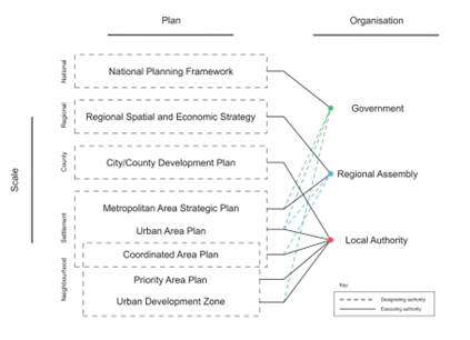
The image illustrates a clear hierarchy of plans and scales, from the national to the neighbourhood level. Less clarity is evident in the link between categories of plan and organisational structure, with overlap and duplication occurring at the settlement and neighbourhood scales. This is significant, as it is urban areas/settlements that are associated with the majority share of carbon emissions globally. It is therefore at the level of districts, towns and cities that coherency in the designation, design, and implementation of spatial strategies is most urgently needed.
To gain a better understanding of the position of settlements within Irish spatial policy, further detail is required. The issues of settlement classification, the definition of settlement boundaries, and the implications of settlement categorisation on the form of future urban development will be covered in the next article in this series.
Glossary
CAP Coordinated Area Plan
CDP City/County Development Plan
LAP Local Area Plan
MASP Metropolitan Area Strategic Plan
NPF National Planning Framework
NPO National Policy Objectives
PAP Priority Area Plan
RSES Regional Spatial and Economic Strategy
SDZ Strategic Development Zone
UAP Urban Area Plan
UDZ Urban Development Zone
References
Government of Ireland (2024) Planning and Development Act 2024.
Government of Ireland (2025) National Planning Framework: First Revision.
Office of the Planning Regulator (2022) Introducing the Planning System: Planning Leaflet 1.
———————————————————————————————————————-
This new blog series is part of a wider initiative within the IGBC to expand our understanding of what a sustainable built environment might be at the neighbourhood and settlement scales. This research strand is part of a study on how different forms of urban expansion can impact the operational energy use of existing settlement types. The research is funded under Research Ireland’s Enterprise Partnership Scheme (Project ID: ESPG/2024/882) and co-funded by IGBC, the designated Enterprise Partner.
News
More news from IGBC
-

Faster decarbonisation of buildings will increase resilience to energy price shocks
Progress has been made on policies to decarbonise our built environment in recent years but the government must... -

Roadstone – Becoming the First Company in Ireland to Achieve Level 5 on the CO2 Performance Ladder
Introduction Roadstone Ltd, one of Ireland’s leading supplier of construction materials, has become the first company in Ireland... -

New research points way toward vibrant, nature-rich neighbourhoods
New research points way toward vibrant, nature-rich neighbourhoods Dublin, 11 May 2026: Better alignment between government policies and... -

Building for Biodiversity: IGBC and Local Authorities Join Forces
Local authorities, environmental experts, and construction professionals convened on the 14th April in Portlaoise for a landmark workshop... -

Wrapping Up Ireland’s CO2 Performance Ladder Pilot Project – A Major Milestone in Green Public Procurement
Ireland’s two-year pilot of the CO2 Performance Ladder (2023-2025), led by the Irish Green Building Council (IGBC) in... -

South East Energy Agency is Hiring
At South East Energy Agency, we’re expanding, and we’re looking for talented people to join us. Current opportunities:...