


Sustainable Urban planning: Settlement Hierarchies and Compact Growth in Ireland
In the first post of this article series, we looked at how plans are structured in Irish spatial...

About the author

In the first post of this article series, we looked at how plans are structured in Irish spatial policy, from the national to the local level. In this follow-up piece, the focus is on how these plans categorise different settlements and what this means in terms of the location and density of future development – key qualities of sustainable urban growth.
The categorisation of settlements is often called a ‘settlement hierarchy’. A settlement hierarchy is a framework for classifying cities, towns and villages according to certain attributes. These may include characteristics such as a settlement’s size (in terms of area or population), its economic function with respect to a surrounding region, or it’s internal spatial structure (e.g. monocentric, polycentric, dispersed). Depending on the purposes of classification, a settlement hierarchy can refer to each of the aspects listed and more.
[ez-toc]
A short overview of Irish settlement hierarchies
In the Irish context, prior to the National Planning Framework, settlement hierarchies had only been applied nationally on two occasions. In Regional Studies in Ireland (1968) – often referred to as the Buchanan Report – the authors proposed a growth-based national settlement hierarchy, which proposed a five-level grouping of towns based on their development potential.
Over thirty years later, the National Spatial Strategy (2002) would outline a settlement hierarchy of Gateways and Hubs, defined in terms of population size and service provision.
Although the examples provided above involve settlement hierarchies commissioned or published by the State, none were issued on a statutory basis. It is only since 2010 that legislation has required local development plans to align with national and regional strategies (Russell et al., 2021, p. 71). That said, current policy demonstrates a variety of settlement definitions and classification techniques which have been adopted across multiple strategies.
Settlement hierarchies in contemporary Irish spatial policy
Contemporary Irish settlement hierarchies are described across five separate documents: the National Planning Framework (2018, 2025); the three Regional Spatial and Economic Strategies (2019-2020); and the Sustainable Residential Development and Compact Settlements guidelines (2024). Each of the five documents proposes a different structure in terms of the number of settlement categories, the naming of settlement types, and the method by which settlements are classified. This is detailed in fig. 01.
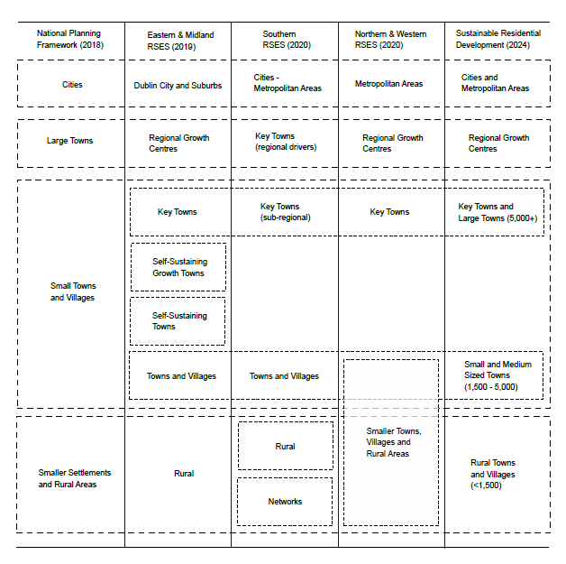
(Note that the revised National Planning Framework (2025) has updated its settlement hierarchy to refer to Regional Growth Centres and Key Towns, but does not provide any description of what these terms mean. That said, it may be assumed that this is due to definitions for these terms being provided for in the Planning and Development Act 2024 – see link to table below.)
Without getting into too much detail here, a complete table of the description for each settlement type is provided in this link. Although the criteria for categorisation isn’t always explicitly articulated, in general, aspects regarding population size and service provision appears to be the primary source for classification.
Differences are evident across the various hierarchies, but three main classifications have emerged with some consistency: Cities and Metropolitan Areas, Regional Growth Centres, and Key Towns. The National Planning Framework designates Cities and Metropolitan Areas, as well as Regional Growth Centres. While the designation of Key Towns falls within the responsibility of Regional Spatial and Economic Strategies.
Why settlement types matter
The classification of settlements in Irish spatial policy is significant for two main reasons. The first is that settlement types are linked to certain categories of plan. Cities each require a Metropolitan Area Strategic Plan (MASP) while Regional Growth Centres and Key Towns may adopt the recently legislated Urban Area Plan (UAP).
The second reason relates to the Sustainable Residential Development and Compact Settlement guidelines (2024). This document issues recommended density ranges (measured in dwellings per hectare – dph) for new developments. The density ranges are dependent on the type of settlement in which development will take place, as well as where the site is located with respect to the settlement area. This essentially means that settlement type designation will shape the density of future development in a given town, village or city.
For cities, densities of 100-300dph in the centre and 40-80dph (up to 150dph) in the periphery are suggested. For Regional Growth Centres, these same figures are 50-150dph and 35-50 (up to 100dph) respectively. While in the case of Key Towns, 40-100dph in the centre and 30-50 in the periphery (up to 80dph) are outlined.
Settlement hierarchies in Ireland: a review
Differences in definition and application
The diagram provided as part of this article shows five unique settlement hierarchies, comprising four to seven settlement types each. The resulting duplication and division can lead to confusion, especially where a similar terminology is used but different definitions apply. A lack of precision regarding the criteria used for classification has also hampered clarity and comparison.
For example, although population size is referenced as a primary criterion for classification, ten Key Towns (Ennis, Kilkenny, Carlow, Tralee, Wexford, Navan, Mullingar, Swords, Naas, and Bray) have a population similar or greater than three Regional Growth Centres (Letterkenny, Sligo, and Athlone). Attributes such as location and role within a wider settlement network may have influenced this decision, but these factors need to be articulated if the purpose behind settlement categorisation is to be understood.
The recent update of the National Planning Framework (2025) is positive in that it demonstrates more consistent adoption of key terms such as Cities and Metropolitan Areas, Regional Growth Centres, and Key Towns. The upcoming revision of the three Regional Spatial and Economic Strategies is an opportunity to more consistently align settlement hierarchies.
The quantity and distribution of settlements
Due to the division of responsibility for settlement designation across national and regional plans, no map showing all three settlement types for the entire country has (to this author’s knowledge) previously existed, with fig. 02 being the first to do so. The result is 5 Cities, 5 Regional Growth Centres, and 32 Key Towns.
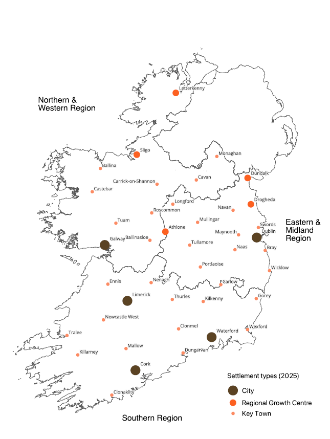
For the purposes of comparison, the 1968 Buchanan Report designated 3 cities and 31 towns across five categories. More recently, the National Spatial Strategy (2002) designated 5 cities (termed ‘Existing Gateways’), 11 Gateways (also termed ‘New Gateways’) and 5 Hubs (fig. 03).

These are different designations with different methods of classification. However, it is notable that the number of settlements categorised at the national/regional scale has fluctuated from 34 (1968), to 21 (2002), to 42 (2018-2020).
This increase in the number of categorised settlements is largely due to the proliferation of Key Towns (32). Unlike previous Irish settlement hierarchies (as in 1968 and 2002), the current framework is the only one in which a Regional Growth Centre or Key Town is present in each county.
As Key Towns are designated separately by the three Regional Assemblies, the expansion of this settlement type may signal a lack of regional coordination and shared definition than to a concerted spatial policy.
In fact, the dispersion of Key Towns may be in direct contradiction of national planning policy, in particular, National Strategic Outcome 1 on ‘compact growth’. As the NPF (2025, p. 3) states: ‘More balanced growth also means more concentrated growth’, wherein more equal population increases at the regional scale will be accompanied by greater agglomeration at the settlement scale. Yet this goal is potentially undermined by the quantity and distribution of settlements proposed.
The following table sets out the National Planning Framework’s (2025) regional population targets, minus that allocated to cities. It then shows the current (2022) population for all Regional Growth Centres and Key Towns per region. Finally, it compares the two, demonstrating that – if Regional Growth Centres and Key Towns were to accommodate all regional population growth targets – then this increase would be substantial; ranging from a doubling of population in the Northern and Western Region, to a 53.6% increase in the Eastern and Midland Region. This raises the question as to whether the regions – and the Northern and Western Region in particular – have an adequate existing network of mid-sized urban settlements to deliver its population targets in a compact, sustainable fashion.
As will be detailed in a future article, these figures also contrast with the growth envisioned for the nation’s five cities, where – most notably – an increase of around 23% is planned for Dublin. The remaining cities (Cork, Limerick, Galway, and Waterford) are expected to grow approximately 42%-47%. This raises the question as to whether the goal of balanced regional growth is achievable if concentration within Ireland’s metropolitan areas is not increased.
| Region | Population target (minus cities) | Current population of Regional Growth Centres and Key Towns | Percentage increase in population |
| Northern and Western Region | 114,000 | 114,125 | 99.9% |
| Southern Region | 162,000 | 228,179 | 71% |
| Eastern and Midland Region | 174,000 | 324,528 | 53.6% |
Table 01: Comparison of regional population targets and existing populations of Growth Centres and Key Towns. Information from the National Planning Framework (2025) and Census 2022 (CSO). Table by the author.
A consequence of this population allocation is not just relevant in terms of where people live but also in determining the form of future development. Nationally, Regional Growth Centres consist of an aggregate population of 153, 273 (CSO, 2022). By comparison, Key Towns equate to 536,448. If future growth was distributed evenly across both settlement categories according to their existing population levels, 22% would be delivered in Regional Growth Centres. The remaining 78% would occur in Key Towns, where comparatively lower densities are permitted by the Sustainable Residential Development and Compact Settlement guidelines (2024).
Irish settlement hierarchies: a potential future
In Irish spatial policy, settlement classification is significant in determining the location of population growth regionally and in shaping the density of development locally. With a framework of settlement types and density ranges now in place, there is an opportunity to better align and expand this relationship. For example, what is the actual existing density of our Regional Growth Centres and Key Towns? Is it similar for all settlements within each category or does it vary? If these places are intended as future growth poles, what additional services may be required with any increases in dwelling density? Aligning a national settlement hierarchy with space standards in this way could further enhance the National Planning Framework’s strategic objectives in achieving more compact growth and sustainable development.
Addendum: settlement definitions in the Planning and Development Act 2024
Discussion of settlement hierarchies in Irish spatial policy requires some reference to the Planning and Development Act 2024. Although many aspects of this Act are yet to come into force, it makes reference to a number of relevant terms and definitions which appear to contradict meanings adopted elsewhere.
-
Settlements/built-up areas
A ‘built-up area’ is defined by the Planning and Development Act 2024 as an aggregation of ‘statistical small areas’ as prescribed by the CSO (p. 74). This appears to refer to the CSO’s definition of settlements or Built-Up Areas (BUA). (The method for the delineation of BUA boundaries is outlined here.)
However, a ‘settlement’ is separately defined by the Planning and Development Act 2024 as a built-up area identified by the CSO, containing a minimum of 50 occupied dwellings, with a maximum distance between buildings of 100m. This appears to adopt the CSO’s 2016 definition of settlement (further information here) which is no longer in use and has been superseded by the BUA methodology.
According to the Act then, a ‘built-up area’ is a BUA – as defined by the CSO for the 2022 census – and a settlement is a BUA which has been previously identified by the CSO’s 2016 methodology. Since the 2016 census identified 874 settlements, while the 2022 census identified 867 BUAs (more here), this would suggest all built-up areas are settlements in terms of the Act. This would mean the Act’s definition of ‘settlement’ is superseded by the Act’s definition of ‘built-up area’.
-
Urban area and towns
An ‘urban area’ is defined by the Planning and Development Act 2024 as a part of a town or city, containing a minimum of 100 buildings each with a maximum distance of 65m of each other, and includes all other urban land cover within this areal range. This definition is the CSO’s method for establishing initial clusters within the BUA methodology (but is not the complete procedure).
A ‘town’ is defined by the Planning and Development Act 2024 as a municipal district with a population over 2000 people. Municipal districts are described in the Local Government Reform Act 2014 as comprising one or more Local Electoral Areas (LEA). Apart from the Dublin local authorities, and Cork City and Galway City councils, all local authorities are divided in municipal districts, equalling 95 in total across the country (more here). As the smallest LEA has a population of over 10,000 (according to 2022 CSO data), this would mean that according to the Act, all municipal districts are defined as towns.
That being the case, if ‘urban areas’ are part of towns, and towns are equivalent to municipal districts, then an ‘urban area’ is any cluster that meet the minimum requirements anywhere in the country’s 95 municipal districts.
Elsewhere, the Planning and Development Act 2024 makes references to ‘part of the urban area of the settlement’, which suggests that urban areas are intended to form subsets or neighbourhoods within settlements. However, since the Act requires ‘urban areas’ to contain a minimum of 100 buildings and defines ‘settlements’ as containing a minimum of 50 occupied dwellings, it is possible to conceive of instances where an urban area could not be formed within a settlement according to this definition. As a result, where references to ‘part of the urban area of the settlement’ occurs, the Act explicitly states that the definition of ‘settlement’ changes to a ‘town or city with a population of at least 1500’ (p. 75).
-
Metropolitan areas
A ‘metropolitan area’ is defined by the Planning and Development Act 2024 as a city and its hinterland, ‘approximating the extent of its commuting zone’ (p. 90). The ‘metropolitan area strategic plan’ or MASP applies to the metropolitan area. However, the Act’s definition of metropolitan area differs from its prior adoption in Irish spatial policy, where metropolitan areas have been defined by either the National Planning Framework or a Regional Spatial and Economic Strategy. In the case of the Dublin Metropolitan Area in particular, this is already defined by statute according to the Dublin Transport Authority Act 2008. The Act’s definition of metropolitan area, though lacking in specifics, is closer in description to the definition of a Functional Urban Area (FUA).
Bibliography
Colin Buchanan & Partners. (1968). Regional Studies in Ireland. Stationary Office.
National Planning Framework. (2018). Government of Ireland.
National Planning Framework: First Revision. (2025, April). Government of Ireland.
National Spatial Strategy for Ireland 2002-2020. (2002). The Stationary Office (Government of Ireland).
Planning and Development Act 2024, Pub. L. No. 34 (2024).
Regional Economic & Spatial Strategy 2019-2031. (2019). Eastern and Midland Regional Assembly.
Regional Spatial & Economic Strategy for the Southern Region. (2020). Southern Regional Assembly.
Regional Spatial and Economic Strategy 2020-2032. (2020). Northern & Western Regional Assembly.
Russell, P., & Williams, B. (2021). ‘Irish urban policy: From benign neglect to national strategic planning’. In K. Zimmermann & V. Fedeli (Eds.), A Modern Guide to National Urban Policies in Europe. Edward Elgar Publishing.
Sustainable Residential Development and Compact Settlements: Guidelines for Planning Authorities. (2024). Department of Housing, Local Government and Heritage.
This new blog series is part of a wider initiative within the IGBC to expand our understanding of what a sustainable built environment might be at the neighbourhood and settlement scales. This research strand is part of a study on how different forms of urban expansion can impact the operational energy use of existing settlement types. The research is funded under Research Ireland’s Enterprise Partnership Scheme (Project ID: ESPG/2024/882) and co-funded by IGBC, the designated Enterprise Partner.
News
More news from IGBC
-

Faster decarbonisation of buildings will increase resilience to energy price shocks
Progress has been made on policies to decarbonise our built environment in recent years but the government must... -

Roadstone – Becoming the First Company in Ireland to Achieve Level 5 on the CO2 Performance Ladder
Introduction Roadstone Ltd, one of Ireland’s leading supplier of construction materials, has become the first company in Ireland... -

New research points way toward vibrant, nature-rich neighbourhoods
New research points way toward vibrant, nature-rich neighbourhoods Dublin, 11 May 2026: Better alignment between government policies and... -

Building for Biodiversity: IGBC and Local Authorities Join Forces
Local authorities, environmental experts, and construction professionals convened on the 14th April in Portlaoise for a landmark workshop... -

Wrapping Up Ireland’s CO2 Performance Ladder Pilot Project – A Major Milestone in Green Public Procurement
Ireland’s two-year pilot of the CO2 Performance Ladder (2023-2025), led by the Irish Green Building Council (IGBC) in... -

South East Energy Agency is Hiring
At South East Energy Agency, we’re expanding, and we’re looking for talented people to join us. Current opportunities:...