


Sustainable Urban Planning: Urban Boundaries and Their Impacts
Previous articles in this series have provided an overview of how spatial policy in Ireland structures plans across...
 Aerial view of Dublin city. Photo credit: Jason Dent
About the author

Previous articles in this series have provided an overview of how spatial policy in Ireland structures plans across scales, defines key terms, and designates objectives. This third post is the last instalment to outline the Irish planning context. It focuses on how urban areas are delineated, how different urban boundaries are adopted in policy, and what this means for the future development of our cities, towns, and villages.
Future articles will examine particular urban design and planning goals across national, regional and metropolitan levels. These will be evaluated in relation to their stated aims, existing spatial structures, and potential impact in achieving more sustainable urban development.
Defining urban areas
What do we mean when we classify an area as ‘urban’? Internationally, the criteria for defining urban areas varies greatly (e.g. in terms of population size, density, etc.) as does the threshold for designation (ranging from 200 to 40,000 people) (UN, 2008).
Methods of delineating settlement boundaries are equally diverse. In its review of settlement boundary types globally, the United Nations (2018) grouped the various approaches under four headings: administrative, morphological, statistical, and functional. These four boundary types are found within Irish spatial policy. To demonstrate their use and application, the case of Dublin will be detailed. These examples are outlined as follows:
- Administrative boundary: Dublin Strategic Planning Area.
- Morphological boundary: Dublin City and Suburbs.
- Statistical boundary: Dublin Metropolitan Area.
- Functional boundary: Core Region.
Administrative boundary: Dublin Strategic Planning Area
Most county boundaries remain little changed since the Local Government (Ireland) Act (1898). While some piecemeal variations have occurred, major alterations have largely occurred in terms of the amalgamation or division of existing borders. This is evident in the abolition and subsumption of a number of town/borough/city councils in the Local Government Reform Act (2014). In the case of Dublin, a restructuring of administrative boundaries took place in 1994 with the Local Government (Dublin) Act (1993) which replaced Dublin County Council with the three local authorities of South Dublin, Fingal, and Dún Laoghaire-Rathdown.
In Irish planning policy, these three authorities – along with Dublin City – may be referred to as the Dublin Strategic Planning Area (SPA). This is one of three SPAs in which the Eastern and Midland Regional Assembly is administratively arranged (EMRA, 2019, p. 14), the others being the Midland Region and the Eastern Region.
Administrative boundaries are primarily relevant to spatial policy concerns in that they determine city/county development plan extents, as well more locally specific plans. It is not unusual though to find the built-up area or morphological boundary of a settlement extend across a single administrative border. The most extreme example of this is Dublin, which is the only settlement in the country whose built-up area extends across three or more local authorities (and arguably now extends across six, including Meath and Wicklow).
Morphological boundary: Dublin City and Suburbs
‘Dublin City and Suburbs’ is the name given to the Dublin ‘Built Up Area’ (BUA). A BUA is a definition for urban settlements, based on proximity between buildings, devised by the CSO, in collaboration with Tailte Éireann and the Department of Housing, Local Government and Heritage. It was first applied to the results of the 2022 census (CSO, 2023). Further information on the method can be found here. (Note 1)
BUA settlement boundaries are significant as they feature in the National Planning Framework (2025) as the areal extent in which National Policy Objectives (NPO) 4, 7, 8 and 9 apply.
NPO 4 requires that 50% of national population growth be situated within the existing built-up footprint of the cities of Dublin, Cork, Limerick, Galway and Waterford; NPOs 7, 8, and 9 mandate the percentage of new dwellings that must be situated within existing built-up footprints. Nationally, this figure is 40% (NPO 7). For the five cities, 50% of new dwellings must be within the existing settlement boundary (NPO 8), while the target for all other settlements is 30% (NPO 9).
In relation to these targets, the National Planning Framework (2025, p. 153) suggests that 20% of the population growth intended within existing built-up areas could be diverted to locations outside the morphological settlement boundary but within the ‘wider metropolitan area’(Note 2). This wider metropolitan region referred to is officially known as a Metropolitan Area Strategic Plan (MASP). In the context of Dublin, the relevant MASP is known as the ‘Dublin Metropolitan Area’.
Statistical boundary: Dublin Metropolitan Area
The National Planning Framework (2018) first established the criteria by which a Metropolitan Area Strategic Plan may be determined. This includes:
– The functional urban area of the city;
– Commuting patterns;
– Geographical features;
– Existing boundaries which form part of a relevant NTA transport strategy (p. 134).
In the case of the Dublin MASP, the boundary of the plan must align with the Dublin Metropolitan Area, as defined in the NTA’s Transport Strategy for the Greater Dublin Area 2016-2035 (2016) (NPF, 2018, p. 134).
The Dublin Metropolitan Area, as it exists in its current form, is an amended outline based on a boundary that originates from the Strategic Planning Guidelines for the Greater Dublin Area (1999). It was subsequently adopted by the National Spatial Strategy (2002), the Regional Planning Guidelines: Greater Dublin Area 2004-2016 (2004) and amended in the Regional Planning Guidelines for the Greater Dublin Area 2010-2022 (2010). The precise origin of the boundary is unknown, as no document describes the rationale or method behind its delineation. However, based on the written description, it appears that the DMA is based on the amalgamation of Electoral Districts and townlands (or more recently, Census Small Areas). In other words, the boundary is based on the aggregation of pre-existing statistical units.
The definition of the Dublin Metropolitan Area is important as it determines where the 20% growth allowances provided for in the National Planning Framework may be allocated. For example, the Regional Spatial and Economic Strategy for the Eastern and Midland Regional Assembly (2019) specifies that the allowed 20% of transferable population growth only applies to Bray, Maynooth, and Swords (designated as ‘Metropolitan Key Towns’) and only if the proposed development is compact in form and located on a high-capacity public transport route (p. 113).
Functional boundary: Core Region
The ‘Core Region’ is a term applied by the Eastern and Midland Regional Assembly (2019) to an area based on a particular measure of Dublin’s commuter catchment. It is understood as the ‘peri-urban hinterlands’ of the Dublin Metropolitan Area (EMRA, 2019, p. 18). It includes all Electoral Districts where 15% or more of employed residents work within the DMA, based on 2016 census data.
This approach is based on the OECD definition of ‘functional urban areas’. The OECD methodology features a process of ‘urban centre’, ‘city’, and subsequent ‘commuter zone’ definition. The method adopted by the EMRA assumes the Dublin Metropolitan Area boundary as the equivalent ‘city’ zone for this purpose. Further information on the OECD method for delineating Functional Urban Areas is available here.
Based on this method, the Core Region extends beyond the EMRA area (see Fig. 1.9, RSES, 2019) and is therefore truncated to align with the administrative boundaries of the Regional Assembly (see Figs. 3.1 & 4.2, RSES, 2019).
Of note is that a means of defining urban regions through the measurement of a primary settlement’s catchment area is not a new approach in Irish spatial policy. Previous versions include the Wright Report’s (1967) description of ‘Metropolitan Dublin’ and the Eastern Region Settlement Strategy 2011 (1985) approach to defining its eleven ‘Sub-Regions’.
Overlaps
Although these four urban boundaries are notionally distinct, in reality, there are often overlaps and interdependencies among their criteria and outlines. In the case of Dublin, for instance, the functional urban area (Core Region) is derived from the Dublin Metropolitan Area acting as the ‘core city’. While the process for delineating the morphological boundary (Dublin City and Suburbs) is set up to align with existing statistical units (Census Small Areas).
Conclusion
In summary, four different approaches to defining urban areas are actively in use within Irish spatial policy. These are:
– Administrative boundaries;
– Morphological boundaries;
– Statistical boundaries;
– Functional boundaries.
The four boundaries and their corresponding equivalent for Dublin are mapped in Figure 01.
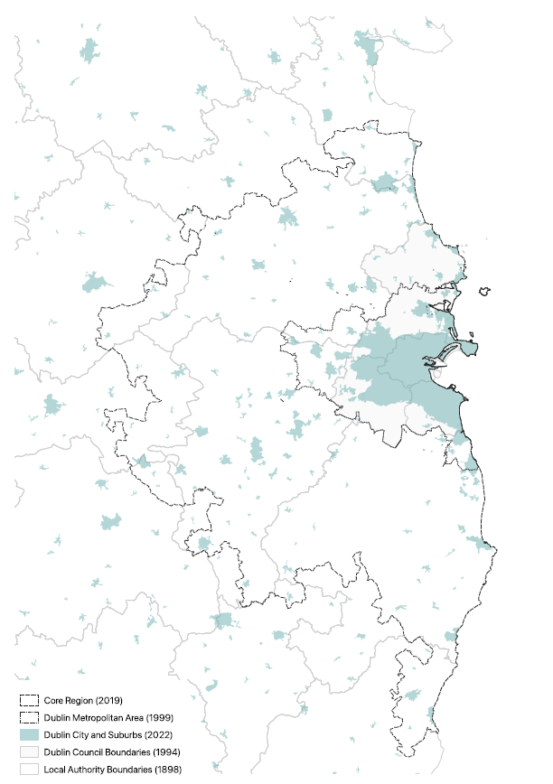
Each of the different methods of boundary delineation is adopted for unique purposes:
– The administrative boundary determines local-level planning policy, decision-making and development plan extents.
– The morphological boundary determines the location of population and housing targets.
– The statistical boundary determines the location of potential metropolitan expansion.
– The functional boundary influences regional design strategy.
This review shows that multiple boundary definitions may exist for the same settlement. These different delineations can be useful in providing insights relative to the data used and in guiding future urban design and planning decisions. In adopting this approach specificity and clarity is key so that the origin and purpose of individual boundaries can be understood and confusion between boundary types is avoided.
In future articles, the impact of these different boundaries – particularly in relation to population growth and densification – will be reviewed in further detail.
Bibliography
Central Statistics Office (2017) Census 2016 Boundary Files – CSO – Central Statistics Office, cso.ie.
Central Statistics Office (2023a) Census 2022 Urban Boundaries and Built Up Areas – CSO – Central Statistics Office, cso.ie.
Eastern Region Settlement Strategy 2011 (1985). Eastern Regional Development Organisation.
National Planning Framework (2018). Government of Ireland.
National Planning Framework: First Revision (2025). Government of Ireland.
National Spatial Strategy for Ireland 2002-2020 (2002). The Stationary Office (Government of Ireland).
Regional Economic & Spatial Strategy 2019-2031 (2019). Eastern and Midland Regional Assembly.
Regional Planning Guidelines for the Greater Dublin Area 2010-2022 (2010). Dublin Regional Authority / Mid-East Regional Authority.
Regional Planning Guidelines: Greater Dublin Area 2004-2016 (2004). Dublin Regional Authority / Mid-East Regional Authority.
Sustainable Residential Development and Compact Settlements: Guidelines for Planning Authorities (2024). Department of Housing, Local Government and Heritage.
Transport Strategy for the Greater Dublin Area 2016-2035 (2016). National Transport Authority.
United Nations Department of Economic and Social Affairs. (2008). United Nations Demographic Yearbook 2005 (Vol. 57).
United Nations, Department of Economic and Social Affairs, Population Division. (2018). World Urbanization Prospects: The 2018 Revision, Methodology (No. ESA/P/WP/252).
Wright, M. (1967) The Dublin region: advisory regional plan and final report. Stationary Office.
Notes
- The 2022 BUA definition involves a multi-step method based on building proximity and alignment with existing statistical boundaries. In first step, groups of buildings comprising 100 buildings or more, and where a maximum distance of 65m exists between buildings, are identified. It is then determined whether these groups of buildings are within 500m of other groups. This collection of building groups or clusters then generates a boundary line that incorporates the plots in which each building sits, as well as any parcels featuring urban land uses. This is termed a “hull”. The “hull” is assessed for alignment with the CSO’s Statistical Small Areas (SSA). Where 60% or more of an SSA’s area lies within the hull, it is incorporated into the final BUA boundary (CSO, 2023). Note that unlike previous building proximity methods adopted by the CSO for defining urban settlements, all building types are included, not only dwellings or occupied dwellings. For example, the previous (and original) definition of ‘Dublin City and Suburbs’ was first applied in the 2011 census. This method extended existing legally defined towns based on a 100 metre building proximity rule, to include all occupied dwelling within 100 metres of an existing building, with additional mapping data taken into account when extending boundaries. Extensions generally included the plot on which a dwelling was located or alignment with other physical features such as roads. This method of delineation would also be used in the 2016 census (CSO, 2017). While no exact equivalent definition exists for ‘Dublin City and Suburbs’ prior to 2011, an earlier building proximity measure for defining urban settlements was adopted by the CSO between 1991 and 2006.
- Note that this statement was previously made as National Policy Objective 68 in the first iteration of the National Planning Framework (2018). It appears to have lost its status as an NPO in the revised NPF.
News
More news from IGBC
-

Faster decarbonisation of buildings will increase resilience to energy price shocks
Progress has been made on policies to decarbonise our built environment in recent years but the government must... -

Roadstone – Becoming the First Company in Ireland to Achieve Level 5 on the CO2 Performance Ladder
Introduction Roadstone Ltd, one of Ireland’s leading supplier of construction materials, has become the first company in Ireland... -

New research points way toward vibrant, nature-rich neighbourhoods
New research points way toward vibrant, nature-rich neighbourhoods Dublin, 11 May 2026: Better alignment between government policies and... -

Building for Biodiversity: IGBC and Local Authorities Join Forces
Local authorities, environmental experts, and construction professionals convened on the 14th April in Portlaoise for a landmark workshop... -

Wrapping Up Ireland’s CO2 Performance Ladder Pilot Project – A Major Milestone in Green Public Procurement
Ireland’s two-year pilot of the CO2 Performance Ladder (2023-2025), led by the Irish Green Building Council (IGBC) in... -

South East Energy Agency is Hiring
At South East Energy Agency, we’re expanding, and we’re looking for talented people to join us. Current opportunities:...